Lewotobi is a twin volcano located in the southeastern part of the island of Flores, Indonesia, it has two peaks; the Lewotobi Laki-laki (Male Lewotobi) and Lewotobi Perempuan (Female Lewotobi) stratovolcanoes, the more active Lewotobi Laki-laki is about 2.1 km northwest of the taller Lewotobi Perempuan.
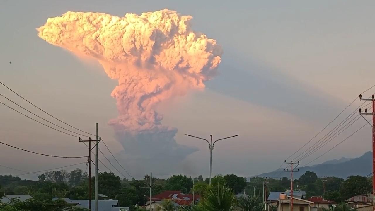
On 21 March, Lewotobi Laki-laki erupted, sending ash clouds over 8 km high. Authorities raised the alert to the highest level, and Jetstar canceled some flights to Bali. The eruption followed smaller ones since 13 March. One person was injured during the evacuations, although the details reported were unclear. Bali airport remained open, but seven international flights were canceled. The geological agency warned of lava floods and continued activity. Lewotobi Laki-laki erupted again on 18 May, prompting authorities to raise Indonesia’s highest volcanic alert level. Lewotobi Laki-laki erupted on 17 June, sending ash clouds 11 km high, prompting authorities to raise Indonesia’s highest volcanic alert level again, with a plume visible from a distance of 90 km to 150 km. Multiple flights were cancelled due to the amount volcanic ash released into the atmosphere. Two major eruptions occurred on 7 July, ejecting debris as far as 8 km away and producing pyroclastic flows that reached 5 km from the crater and an ash cloud 13 km high. At least 24 flights were cancelled in Bali.
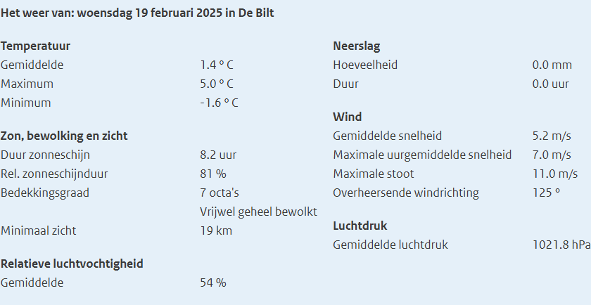
Woensdag; Wat eten we vandaag?; Asteroid 2024 YR4; Etna; Metronet Amsterdam; Trump; Phishing; Bestaanszekerheid vooral voor de allerrijksten: Familiestichting; Day Against Homophobia in Football; Levensverwachting vs levenstijl; Lichtpuntjes tegen Kanker.
Rond de submarienecalderavulkaanKolumbo (Grieks: ηφαίστειο Κολούμπος), in de Egeïsche Zee ongeveer 8 km noordoostelijk van het Griekse eiland Santorini, onderdeel van hetzelfde vulkanische complex, zijn sinds eind januari 2025 vele aardbevingen te voelen.
De Griekse overheid heeft op 6 februari 2025 de noodtoestand afgekondigd voor het eiland Santorini, nadat de populaire toeristenbestemming in een week tijd opgeschrikt was door honderden onderzeese aardbevingen. De zwaarste daarvan vond plaats op 5 februari tussen Santorini en het eiland Amorgos, en had een kracht van 5.2 op de schaal van Richter.
Starting from late September 2024, Ethiopia has experienced series of earthquakes ranging from 4.8 to 5.8 Richter magnitude scale with initial epicenter from Afar Region‘s Awash Fentale and spread across much of central Ethiopia.
On 6 October 2024, a series of earthquakes with 4.9-magnitude tremor occurred starting to Afar Region‘s Awash Fentale area and spread into Oromia Region, causing widespread concern. The epicenter was about 23 km northeast of Awash as the tremor occurred at the depth of 10 km and the shaking was felt across central Ethiopia. Over 30 homes collapsed in Afar while thousands fled to neighboring area as refuge. Pubic officials responded by shutdown of transportation infrastructure in the tremor zone to investigate the damage and power outages were likely to be measured. On 13 October, a magnitude of 4.6 quake happened in Oromia Region at around 07:37. The shaking affected throughout central and eastern Ethiopia, such as southern Afar, southern Amhara, and central Oromia regions, northwestern Somali Region, and the capital Addis Ababa. Also on 16 October, an earthquake was observed in Metehara area in Oromia at 23:11 local time with 4.8 magnitude registered. The Volcano Discovery discovered that the tremor struck at the shallow depth of 10 km beneath the Earth surface. The German Research Centre for Geosciences (GFZ) was the first to detail seismic event, providing crucial data for understanding its effects. According to initial reports, residents nearby the epicenter were likely saw a quake, though caused minimal damage.
On 29 December, an earthquake reoccurred in afternoon and until in the morning 5.1 magnitude. Prior to this, two earthquakes occurred in a week. In January 2025, 10 earthquakes were recorded within 24 hours in a week. According to the US Geological Survey, these multiple quakes were 4.3 to 5.1 on the Richter scale occurred around Fentale volcano in Awash. Since 3 January 2025, signs of a volcanic eruption began to appear, prompting authorities to move residents to temporary shelters. The Ethiopian Geological Institute posted a video in Facebook page depicting dust and smoke emerging from a volcano in Awash Fentale in Afar region. On that day, another quake strike with the magnitude 5.8 in epicenter of Addis Ababa. It was at a shallow depth of 10 km according the US Geological Survey and the German Research Centre for Geosciences.
Shiveluch, een van de meest actieve vulkanen op het Russische schiereiland Kamtsjatka, barstte donderdagavond uit; de uitbarsting zond aswolken tot 15 kilometer de lucht in en bedekte grote gebieden met stof.
New trigger proposed for record-smashing 2022 Tonga eruption: previously unstudied data from a seismic wave, detected 750 kilometers from the seamount, may bolster tsunami early-warning systems.
Fifteen minutes before the massive January 2022 eruption of the Hunga Tonga-Hunga Ha’apai volcano, a seismic wave was recorded by two distant seismic stations. Now, researchers argue that similar early signals could be used to warn of other impending eruptions in remote oceanic volcanoes. The researchers propose that the seismic wave was caused by a fracture in a weak area of oceanic crust beneath the volcano’s caldera wall. That fracture allowed seawater and magma to pour into and mix together in the space above the volcano’s subsurface magma chamber, explosively kickstarting the eruption. The research was published in Geophysical Research Letters, an open-access AGU journal that publishes high-impact, short-format reports with immediate implications spanning all Earth and space sciences. The results build on the researchers’ previous work monitoring remote volcanoes. In this case, the Rayleigh wave, a type of seismic wave that moves through the Earth’s surface, was detected 750 kilometers (approximately 466 miles) from the volcano.
Woensdag; Wat eten we vandaag?; Fagradalsfjallvulkaan – uitbarsting; Vreemdelingenwet Mikael en Gohar blijven hier!; I Have a Dream; Bommen Berend; Klimaatzaak tegen de EU; Paralympische Spelen.
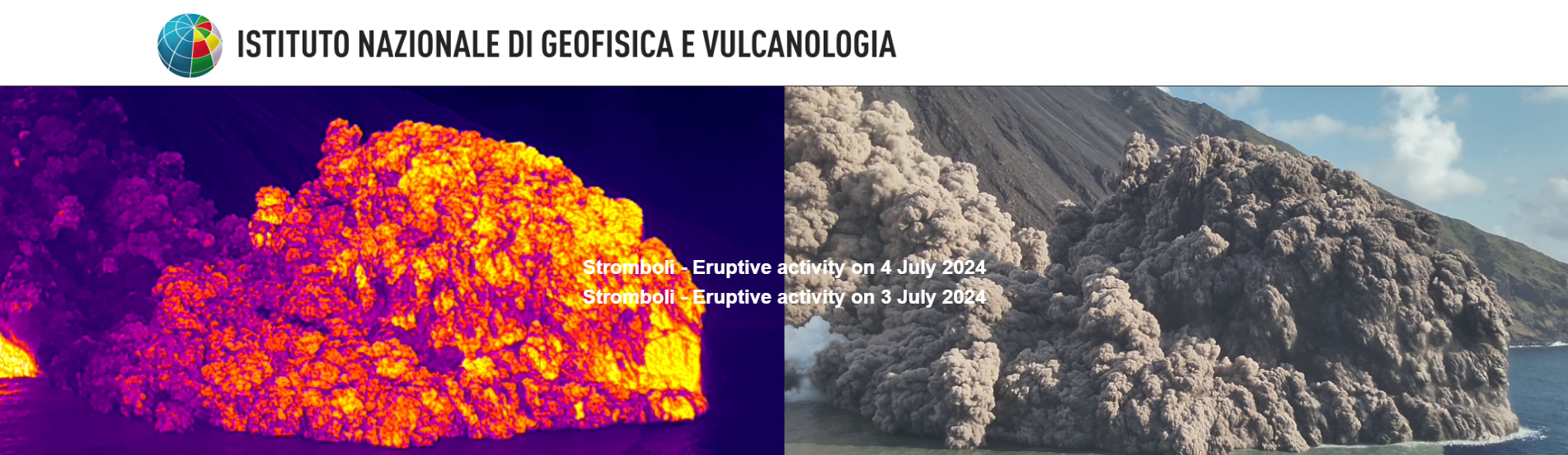
On 3 July 2024, Stromboli erupted along with Etna, as Protezione Civile issued the highest alert level.
Italy’s Mount Etna and the smaller Stromboli volcano spewed hot ash and lava, raising alert levels on the Mediterranean island of Sicily and forcing a temporary shutdown of the airport in Catania, disrupting flights. Etna, one of the world’s most active volcanoes, has seen intense activity in recent days, lighting up the sky near Catania, while Stromboli off the northern Sicilian coast spilled lava into the sea.
De Marsili is de grootste onderwatervulkaan van Europa en ligt in het zuiden van de Tyrreense Zee, ten noorden van Sicilië.
Het massief strekt zich uit over 2000 km². De voet ligt 3000 m onder de zeespiegel, de top 500 m. De vulkaan werd in de jaren 1920 ontdekt en vernoemd naar de Italiaanse wetenschapper Luigi Fernando Marsili. De vulkaan wordt permanent bewaakt met seismograaf en magnetometer omdat een uitbarsting of grote aardverschuiving op de flanken een tsunami kan veroorzaken.
Wat is de activiteitsstatus van Marsili, de grootste vulkaan in Europa en de Middellandse Zee? Is het waar dat het actief is? Bestaat er een tsunami-gevaar dat verband houdt met het mogelijke uitlokken van een grote aardverschuiving (laterale instorting)? Het Italiaanse Nationaal Instituut voor Geofysica en Volcanologie (INGV) heeft er in 2015 over gesproken, maar recente studies hebben bijgedragen aan een verdere verdieping van de kennis van de morfologie, de interne structuur en het gevaar dat verband houdt met mogelijke tsunami’s.
…bij A3veen.nl, sinds 29-04-2003 de webplek van Aaldrik Adrie (A3) van der Veen, met een weBLOG vol weetjes die het delen waard zijn, onder het motto: “Zie de wereld door de ogen van A3…”